
New version 1.1 !
 Introduction
PATHMATRIX is a tool to compute matrices of effective
geographic distances among samples, based on a least-cost path algorithm.
Punctual locations (points) or zones encompassing sample data points (polygons)
are used in conjunction with a species-specific friction map representing the
cost of movement through the landscape. Three different types of distances can
be computed. 1) least-cost distance, 2) length of the least-cost path, 3)
Euclidean distance. Matrices of effective distances can then be exported
to other software to test, for example, for isolation by distance. The use of
effective distances allows to investigate the role of the environment on the
spatial genetic structuring of populations. Especially for habitat specialists,
least-cost distances may give a more realistic measure of spatial isolation (or
its inverse, connectivity) than standard Euclidean distance (e.g. Chardon et al. 2003; Coulon et al. 2004)
PATHMATRIX is an extension to the Geographical Information System (GIS) software ARCVIEW 3.x, and is written in the language Avenue. It needs to be used in conjunction with the ARCVIEW module Spatial Analyst.
The goal of this online manual is to describe the user interface and the formats of input and output files.
Related articles
This software was developed by Nicolas Ray, and the reference to cite is:
Ray N. (2005) PATHMATRIX: a GIS tool to compute effective distances among samples, Molecular Ecology Notes, 5: 177-180
For a list of papers having used PathMatrix, click on this Google Scholar link.
What's new in version 1.1
The release of version 1.1 adds two functionnalities:
- It is now possible to use unprojected points or polygons in a projected View. The distances are then obtained in map units (e.g. meters, instead of decimal degrees as in version 1.0) and least-cost paths can be correctly displayed as graphs in the View or saved in an unprojected shapefile. See Important notes on projections below.
- It is now not required to have a grid selected in the View when only Euclidean distances are computed
Download and installation
Download:
pathmatrix1.1.zip : PATHMATRIX 1.1 ArcView extension
pathmatrix_data.zip : Zip file containing a friction grid (and its legend friction.avl), a point shapefile and a polygon shapefile
Installation:
2. Unzip pathmatrix1.1.zip, and place a copy
of pathmatrix1.1.avx in your extension folder
3. In ARCVIEW, go to ‘File/Extensions…’, and load the
PATHMATRIX extension. Make sure that the Spatial
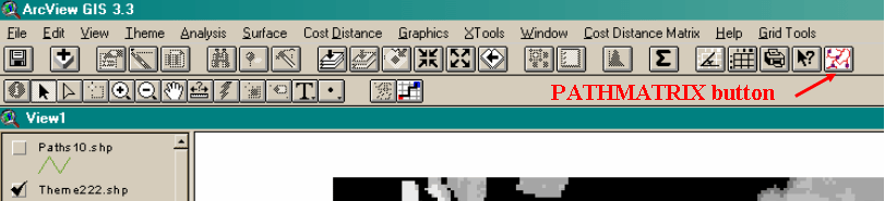
Analyst extension is also loaded. Once in a View, the PATHMATRIX user
interface is accessed by clicking the PATHMATRIX button that appears on the
right side of the list of buttons:
User
interface
Once
clicked, the PATHMATRIX button accessed the user interface, which is described
below.
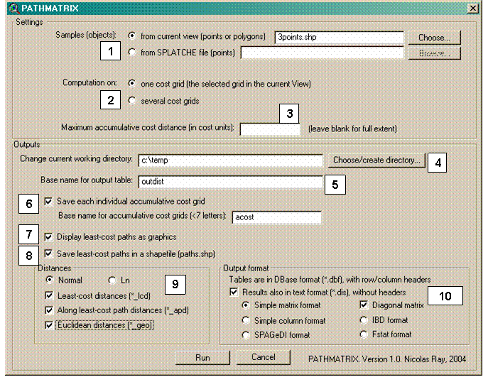
Figure 1 PATHMATRIX user
interface.
- Inputs
-
Outputs
Input files
Sample
coordinates can either be described through an existing point shapefile
displayed in the current View, or through a simple (text) coordinates file in
SPLATCHE format (Currat M et al.
2004). If an existing point shapefile is used, it MUST have an “Id” field
(numbers or strings) with unique identifiers.
The
format of the simple coordinate file is described below.
Sample
coordinates file (SPLATCHE format, *.asc)
A file with the extension ".sam" allows to specify the coordinates of
the samples, as well as the number of genes sampled in each population (see SPLATCHE online help for more information).
On the first line of this file, the user must specify the number (integer) of
samples. The second line is reserved for the legends. Then, each line defines a
sample with 4 fields separated by "tabs" (not “spaces”!).
Example of sample coordinates file:
3
#name #size #lat #long
spl1 40 35.8 12.3
spl2 25 40.1 13.1
spl3 35 34.1 14.9
where #name is the name
of the sample, #size is the sample
size, #lat is the
latitude, and #long is the
longitude
The field #size is not used
in PATHMATRIX and is not compulsory, so that the file can be simplified as
follow:
3
#name #lat #long
spl1 35.8 12.3
spl2 40.1 13.1
spl3 34.1 14.9
In the above example, latitudes and longitudes are in
decimal degrees. It is possible to use coordinates in other units, given that
1) your friction grid(s) are in the same units and projection, and 2) that your
are using PATHMATRIX in an unprojected View (see the important note on
projection).
An example with coordinates units in meters:
3
#name #lat #long
spl1 5889000 712000
spl2 5895000 717000
spl3 5935000 738000
The use of a Sample coordinates file will generate a
new point shapefile (splatchepoints.shp) that will be saved in the current
working directory. Because PATHMATRIX must use an “ID” field in the input and
output files, each input sample will be assigned a numeric ID starting at 1.
Fiction grid(s)
One or several friction grid files can be used. These
grids can either be integer or float, but keep in mind that computation is
usually slower with float grids.
The first option is to use the selected grid in the
current view. In this case, the base name for the output distance tables(s) can
be set. Another option allows to save the individual accumulative cost maps.
There is one accumulative cost map per sample, and these maps from which the
least-cost distances are computed. Saving and visualizing these maps can often
be useful to check that adequate friction values have been chosen. If this
option is chosen, the base name of these grids can be set. Each grid name will
be composed of the base name plus an increasing ID number. If grids with a
similar base name already exist in the current working directory, successive
grids will have higher ID numbers.
The second option is to use several friction grids,
in a way similar to a batch process. In this case, the user chooses a set of
grids on disks. It is not possible to save the accumulative cost grids in this
case, and the names of the output distances tables will correspond to the name
of each corresponding friction grid.
Computed distances
Two
types of effective distances, and one type of Euclidean distance can be
computed with PATHMATRIX. The distances are computed among all input samples
(point or polygons) in a pairwise fashion. With polygons, distances are
computed using closest edge-to-edge. The natural logarithm of distance can be
alternatively chosen when computing distances. Although the log of an Euclidean
distance is often used when comparing genetic and geographic distances, it is
not clear yet what a log of a least-cost distance is. Users should be aware of
that if they use it in their work.
It
is possible in PATHMATRIX to display the computed least-cost paths on the view,
or to save them in a polyline shapefile. There are always n*(n-1)/2 paths,
where n is the number of points or polygons. By definition, the least-cost
distance (and the length of a least-cost path) is equal when computed between
points A and B or between points B and A. Therefore, PATHMATRIX only computes
one least-cost path between any given pair of points (or polygons). However,
the least-cost path that is drawn in the view can be slightly different between
A and B or between B and A, and this can be visible. This is due to the fact
that sometimes, in a zone with uniform friction, there are several
possibilities to draw the least-cost path. ArcView uses a deterministic method
to choose to go “right” or “left”. Hence, the minor visual differences between
paths. However, despites these alternatives least-cost path drawing, the total
least-cost distance or the length of the least-cost path is identical.
Individual
least-cost paths can be selected in a View, so that it is possible to display
or save only a subset of the whole set of paths. After selection, a subset of
paths can be saved by using the tool “Theme/Convert to Shapefile…”.
Description
of the three available distances follows.
Least-cost distance
This distance is the accumulative cost distance of the least-cost path. It is
the minimum distance in cost units to reach the target point (or polygon) from
the source point (or polygon).
Along least-cost path distance
This distance is the length (in map units., e.g. meters) of the least-cost
path. It is equivalent as “walking” on the least-cost path and recording the
total distance. The map units of the View must be defined to compute these
distances.
Euclidean distance
This distance is the standard Euclidean distance (“as the crow flies”) between
the target point (or polygon) and the source point (or polygon). The map units
of the View must be defined to compute these distances.
Output formats
Apart
from the standard dBase format (*.dbf) that can be opened in Excel, several
output text formats can be chosen. Below are examples of output matrices
computed among 3 sample locations.
Simple
tab-delimited text diagonal matrix
0.000000
158934.328125 0.000000
257079.937500 190815.437500 0.000000
Simple
tab-delimited text square matrix
0.000000 158934.328125 257079.937500
158934.328125 0.000000 190815.437500
257079.937500 190815.437500 0.000000
Single
column text format
158934.328125
257079.937500
190815.437500
IBD
single column text format (Bohonak 2002)
GEOGRAPHIC_DISTANCE
1 2 158934.328125
1 3 257079.937500
2 3 190815.437500
SPAGeDI
matrix format (Hardy & Vekemans 2002)
M3 ID1 ID2 ID3
ID1 0.000000 158934.328125 257079.937500
ID2 158934.328125 0.000000 190815.437500
ID3 257079.937500 190815.437500 0.000000
END
FSTAT
single column text format (Goudet 1995)
Effective distances computed
with PATHMATRIX
3
pathdist (out_fstat_lcd.dis)
158934.328125
257079.937500
190815.437500
An important note on projections
In ARCVIEW 3.x, it is possible to work either in a
projected or in an unprojected View, and with projected and/or unprojected
data. Working with projections is often required, but is sometimes cumbersome
when lots of data in different projections are used. The user should
familiarize himself or herself with how to efficiently work with projections in
ARCVIEW.
The following table shows how to handle each specific
case when using projected View/data with PATHMATRIX.
|
Case |
View |
Sample shapefile (points or polygons) |
Friction grids |
Computation of distance matrices in PATHMATRIX |
Display of least-cost path graphs and saved least-cost paths in
PATHMATRIX |
|
A |
unprojected |
unprojected |
unprojected |
|
|
|
B |
“ |
unprojected |
projected |
|
|
|
C |
“ |
projected |
projected |
|
|
|
D |
“ |
projected |
unprojected |
|
|
|
E |
projected |
unprojected |
projected |
|
|
|
F |
“ |
unprojected |
unprojected |
|
|
|
G |
“ |
projected |
projected/ |
|
|
-
the cases A and C
are likely to be encountered by most users. PATHMATRIX handles distances and
display of least-cost paths correctly;
-
with any of the
four cases represented by grey lines (B, D, F and G), vector data (points or
polygons) and grids do not match spatially and are wrongly displayed in the
View. To avoid wrong analysis, ArcView users should never allow such cases to
happen;
-
with case E, PATHMATRIX 1.1 handles correctly
the computation of distances in map units (e.g. meters), and is also able
to display or save least-cost paths (in a unprojected shapefile). Alternatively
to this case, the user can also work with a projected sample shapefile in
an unprojected View, which is equivalent to case C. To obtain a projected
sample shapefile from an unprojected sample shapefile, the user can use the
tool “Theme/Convert to Shapefile” while in the original projected View. By
answering “yes” at the question “Do you want the new shapefile to be saved
in the projected units?”, the shapefile is projected and can then be used
in a unprojected View (case C).
Limitations and other notes
-
When creating a
new folder for the working directory, be sure to click again on the newly
created directory to select it.
-
When using a
sample shapefile with a large numbers of points or polygons, or when using
several large friction grids in the batch process, you might encounter the
following Error message:
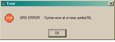
The typical reason for this message is due to limitations in the Spatial Analyst engine. During an ArcView session, Spatial Analyst can only be called about 32'000 times. After that, ArcView becomes unstable and eventually crashes with this type of error message. When you use of lot of points in Pathmatrix (typically more than 150 ), this limit is usually reached, and ArcView crashes. The same situation can also appear when you use much less points (or polygons) in batch mode, by using several cost grids. In that case, the accumulation of Spatial Analyst calls can also add up to the limit and ArcView crashes. Altough there is no solution to avoid the first type of crash (with one grid and too many points), for the second type (few points, but many grids in batch mode), you can always close ArcView after the crash, restart your project and launch Pathmatrix on the remaining set of grids. Remember that restarting ArcView resets to zero the number of calls to the Spatial Analyst engine.
Other reasons for this message, altough less likely,
can be a lack of available memory (RAM). Check that you are not using virtual
memory (swapping) by looking at the task manager of Windows. If it's the case,
you can either add RAM, or try to resample your grid to a lower resolution.
Acknowledgment
I am grateful to Thomas Broquet for feedbacks on an earlier version of this extension. The development of PATHMATRIX was possible through a Swiss postdoctoral NSF grant n° PBGEA-101314 while I was working at the Environmental Science Lab of the University of Melbourne, Australia.
References
Bohonak
AJ (2002) IBD (Isolation by Distance): a program for analyses of isolation by
distance. Journal of heredity 93,
153-154.
Chardon
JP, Adriaensen F, Matthysen E (2003) Incorporating landscape elements into a
connectivity measure: a case study for the Speckled wood butterfly (Pararge aegeria L.). Landscape Ecology 18, 561-573.
Coulon
A, Cosson JF, Angibault JM, et al. (2004) Landscape connectivity influences
gene flow in a roe deer population inhabiting a fragmented landscape: an
individual-based approach. Molecular
Ecology 13, 2841-2850
Currat
M, Ray N, Excoffier L (2004) SPLATCHE: A program to simulate genetic diversity
taking into account environmental heterogeneity. Molecular Ecology Notes 4,
139-142.
Goudet
J (1995) FSTAT: A computer program to calculate F- statistics. Journal of Heredity 86, 485-486.
Hardy
OJ, Vekemans X (2002) SPAGeDi : a versatile computer program to analyse spatial
genetic structure at the individual or population levels. Molecular Ecology Notes 2, 618-620.
For any question or bug report on PATHMATRIX,
please contact Nicolas Ray,
working now at the enviroSPACE Lab at
Last edited on